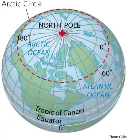
The North Pole is the northernmost point on Earth, situated at a latitude of 90 degrees north. It is often referred to as the geographic North Pole or “True North.” Unlike the equator, which represents the midpoint around Earth’s circumference, the North Pole marks the point where Earth’s axis of rotation intersects its surface in the Northern Hemisphere.
Due to its location in the Arctic region, the North Pole is covered by a constantly shifting and drifting layer of sea ice that sits atop the Arctic Ocean. This ice cover varies in thickness and extent throughout the year, reaching its maximum during the winter months.
Because the lines of longitude converge at the poles, the North Pole doesn’t have a specific longitude like other points on Earth. Any direction from the North Pole is considered south, and it serves as a reference point for navigational purposes, particularly in determining latitude for travelers and explorers.
What Defines North Pole’s Geography?
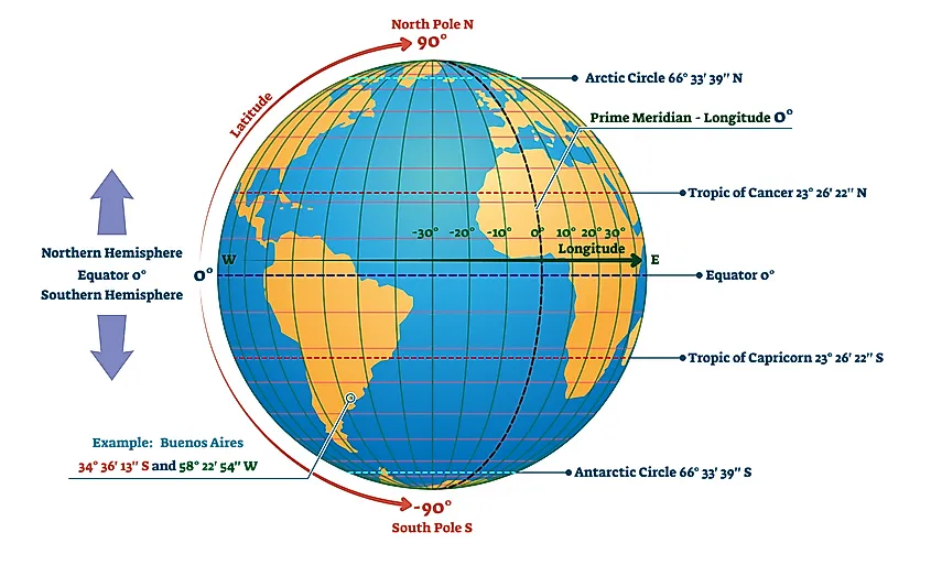
The North Pole is the northernmost point on Earth and is often defined by its geographical coordinates: 90 degrees north latitude. It is the point where the Earth’s axis of rotation intersects its surface and marks the top of the world. At the North Pole, all lines of longitude converge, making it the only location where every direction is south.
Geographically, the North Pole is situated in the Arctic Ocean, covered by shifting sea ice. The region experiences extreme cold temperatures year-round, with long periods of darkness in the winter and continuous daylight during the summer months due to the tilt of the Earth’s axis.
The North Pole is not located on a landmass but rather on a constantly moving ice cap that floats on the Arctic Ocean’s surface. As a result, there’s no specific land or solid ground at the exact coordinates of the North Pole, making it inaccessible for permanent human habitation without special equipment or icebreakers.
How Are the North Pole’s Coordinates Determined?
The determination of the North Pole’s coordinates involves a combination of historical observations, mathematical calculations, and modern technological advancements. Here’s a breakdown of the process:
Astronomical Observations
Historically, astronomers used celestial observations to determine the Earth’s poles. By tracking the movement of stars and celestial bodies, they could establish the North Star (Polaris) as a reference point for locating the North Pole.
Geodetic Surveys
Geodetic surveys involve measurements of the Earth’s surface to determine its exact shape and size. Surveyors use sophisticated instruments to measure angles, distances, and elevation. These measurements help in calculating the Earth’s curvature and triangulating positions.
Satellite-Based Methods
Modern methods heavily rely on satellite technology. Global Navigation Satellite Systems (GNSS), like the GPS (Global Positioning System), GLONASS, and Galileo, use a network of satellites to provide accurate positioning data. These systems allow precise determination of coordinates by receiving signals from multiple satellites and triangulating the receiver’s position on Earth.
Mathematical Calculations
Once the data from various sources (astronomical observations, geodetic surveys, satellite measurements) are collected, mathematical models and calculations are used to reconcile differences, refine accuracy, and establish the precise coordinates of the North Pole.
It’s important to note that the North Pole’s location can slightly vary over time due to factors like the Earth’s crustal movements (plate tectonics), the planet’s wobble (precession), and the shifting of the ice cover in the Arctic region. Therefore, constant monitoring and recalibration are necessary to ensure the accuracy of the coordinates for scientific and navigational purposes.
What’s the Scientific Significance of the North Pole’s Location?
The North Pole’s location serves as a focal point for various scientific disciplines, ranging from geology and climatology to ecology and astronomy, contributing to our understanding of the Earth’s processes and global systems.
Geographic Reference Point
As the northernmost point on Earth, the North Pole serves as a crucial reference point in the geographic coordinate system. It marks the point where the Earth’s axis of rotation intersects the planet’s surface. Understanding and accurately defining this point are fundamental in cartography, navigation, and determining global positions.
Climate and Environmental Studies
The Arctic region around the North Pole plays a vital role in global climate patterns. Studying the Arctic’s ice cover, sea ice extent, temperature changes, and ecological systems helps scientists understand climate change’s impact on polar regions and the planet as a whole.
Earth’s Rotation and Axial Tilt
The North Pole’s location is essential in studying the Earth’s rotation and axial tilt. Scientists monitor changes in the Earth’s orientation and rotational speed by observing the North Pole’s movement, which contributes to our understanding of fundamental concepts in geophysics and astronomy.
Biodiversity and Ecosystems
The Arctic region, encompassing the area around the North Pole, hosts unique ecosystems and biodiversity adapted to extreme cold conditions. Studying these ecosystems provides insights into adaptation mechanisms and the potential effects of climate change on vulnerable species.
Resource Exploration and Economic Interests
The North Pole and its surrounding areas contain valuable natural resources, including oil, gas, minerals, and fisheries. Understanding the region’s geology and resources is crucial for sustainable resource management and potential economic opportunities.
Human Exploration and Innovation
The North Pole’s inaccessibility and extreme conditions have historically attracted explorers and researchers, driving technological advancements and innovative solutions in fields such as polar research, transportation, and survival in harsh environments.
FAQ’s
Does Antarctica have GPS?
Yes, Antarctica has GPS coverage for navigation and scientific research purposes. GPS systems operate in Antarctica, aiding researchers and explorers in location tracking and data collection.
Where is Antarctica on the GPS?
Antarctica appears on GPS systems as a landmass in the southern hemisphere, primarily situated surrounding the geographic South Pole.
Where is the South Pole and North Pole?
The South Pole is located in Antarctica at the southernmost point of the Earth. The North Pole is situated in the Arctic region, specifically in the Arctic Ocean.
Where is Antarctica on Google Earth?
Antarctica is visible on Google Earth software, typically depicted as a continent at the bottom of the globe when viewing the Earth from a virtual globe perspective.
Is Antarctica a no-fly zone?
No, Antarctica is not a complete no-fly zone. There are regulations and restrictions in place for air travel due to its extreme weather conditions and environmental sensitivity. Flights to and within Antarctica are typically managed under strict guidelines for research, tourism, and logistical purposes.
Why is Antarctica not on the map?
Antarctica may not always be prominently displayed on certain maps due to map projections that distort the depiction of the polar regions, making them less visible or easily recognizable. Additionally, the focus of some maps might be on specific regions rather than providing a comprehensive view of the entire globe.
Final Words
In conclusion, the North Pole sits at a latitude of 90 degrees north and serves as a vital point on Earth. It’s a freezing spot covered in shifting sea ice in the Arctic Ocean. Because lines of longitude converge here, there’s no specific longitude. This location helps scientists study climate change, oceans, and nature.
Explorers face challenges reaching this point, but it remains a fascinating destination for adventurers. The North Pole’s coordinates, its importance in science, exploration, and navigation make it an enduringly intriguing spot on our planet.